
CARING FOR THE WHOLE WATERSHED
Watershed Management
Protecting Silver Lake means looking beyond the shoreline.
The health of Silver Lake is connected to the streams, wetlands, forests, roads and developed land throughout its watershed.
LAND AND WATER ARE CONNECTED
Why the watershed matters
A watershed is the area of land where water drains toward a shared body of water. What happens on that land can affect the streams, ponds and lake downstream.
Severe rainfall in 2023 highlighted this connection: runoff can carry phosphorus from fertilizers and other materials into the watershed. Silver Lake experienced its first recorded toxic cyanobacteria bloom in September 2023.
The existing project overview also identifies PFAS found around the Madison Fire Department and in Town wells, and concerns about pollutants in lake sediment left by historical operations, including the lead mine and lumber mill.
The plan is intended to assess risks and recommend practical protection measures, including ways to manage future growth while protecting the watershed.
The Watershed Management Plan
SLAM initiated the Watershed Management Plan project for the Town of Madison to study the Silver Lake watershed and recommend ways to protect it.
The study area
The study covers Madison’s portion of the Ossipee Watershed, including streams, brooks, the Chain of Ponds, Cooks Pond and Silver Lake.
A watershed management plan will also enable Madison to apply for additional state and federal funding, such as Watershed Assistance 319 grants, to help implement watershed conservation practices.
PROJECT FUNDING
Up to $100,000 approved in 2024
SLAM secured approval for Madison to borrow up to $100,000 through the New Hampshire Clean Water State Revolving Fund (CWSRF). The low-interest loan’s principal is to be forgiven at the completion of the study.
SLAM committed to cover the interest so there would be no cost to Madison taxpayers.
How the project began
Madison voters approved the warrant article in March 2025, authorizing the Select Board to proceed. Madison then executed the CWSRF funding contract and formed a steering committee to oversee the project.
The committee issued a public Request for Qualifications in May 2025 and selected FB Environmental in July 2025 to carry out the approximately 18-month study.
FB Environmental →Project steering committee
Dave Scarborough, Chair – Madison Resident, SLAM board member
Bill Lord – Madison Resident, Co-author of CWSRF Application
Bob Newton – Madison Resident, Groundwater Geologist and Professor Emeritus
Matt Vavro – Madison Resident, Geologist
Joe Dame – Representing the Advisory Budget Committee
Ralph Lutjen – Representing the Madison Conservation Commission
Josh Shackford – Representing the DPW
Paul Littlefield – Representing the Madison Planning Commission
PLANNED PROJECT PROGRESSION
From understanding to action
The official schedule runs from July 2025 through January 31, 2027. These broad phases summarize the planned work; they do not indicate that a phase has been completed.
2025
Planning & Data Collection
Early–Mid 2026
Analysis & Modeling
Late 2026
Action Planning & Public Engagement
Through January 2027
Watershed Management Plan
Where we are today
The Watershed Management Plan is an ongoing multi-year project scheduled to continue through January 2027. The project includes data review, watershed and shoreline assessment, modeling, development of water-quality goals and an action plan, public engagement, and preparation of the final Watershed Management Plan.
Project materials and updates are posted below as they become available.
Understanding our watershed
These existing watershed maps offer two ways to explore the land surrounding Silver Lake. Open either map at full size to examine the details.

A three-dimensional view
The landscape view helps put Silver Lake in the context of the surrounding terrain.
Open the 3D watershed map →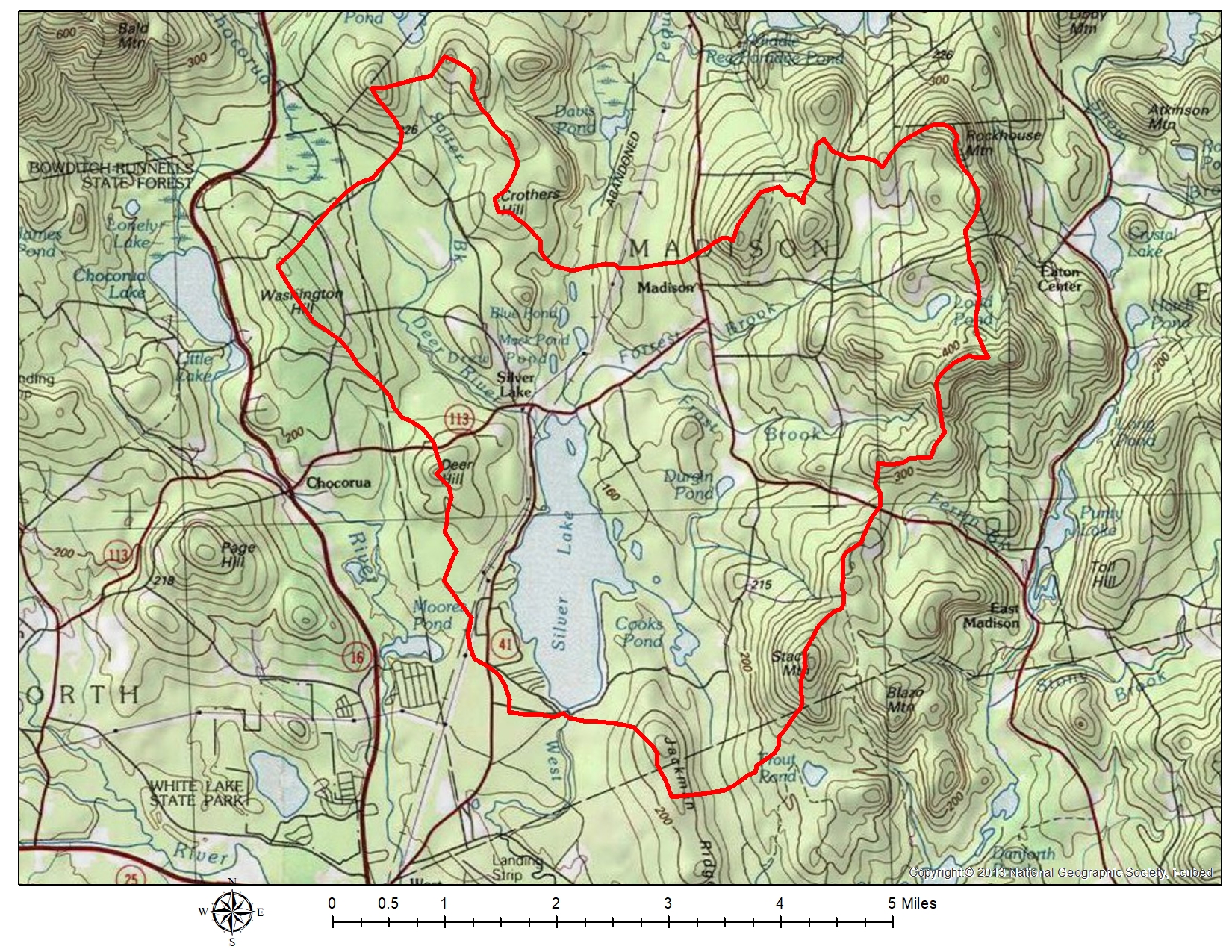
A CLOSER LOOK AT THE LAND
The topographic watershed map
Use this map alongside the three-dimensional view to explore the watershed in more detail.
Open the topographic map →Project documents & updates
Meeting minutes, presentations, project memos and Select Board updates are posted here as they become available.
Stay informed and get in touch
Public project meetings provide opportunities to follow the work. Meeting announcements are shared on SLAM’s Facebook page and through the SLAM email newsletter.
SLAM Facebook page → Subscribe to the SLAM email newsletter → Questions or comments? Email the lake manager →WHAT YOU CAN DO
Lake-friendly choices start at home
Reducing runoff and erosion on individual properties complements the broader watershed-management effort. LakeSmart offers a practical way to learn what you can do on your own property.
LakeSmart is a free, voluntary education and recognition program. Connect with SLAM’s local coordinator to ask questions or arrange a property walkthrough.